The main reason for a rapid decline in the water table can be attributed to our ever-increasing exploitation of ground water resources for meeting the growing water demands of agriculture, domestic and industrial purposes. Increasing urbanization and industrialization have also resulted in ground water pollution causing adverse effects on the health, environment and imbalance in the ecosystem.
The basic purpose of artificial recharge of groundwater is to replenish water into aquifers that have been depleted due to excessive ground water extraction.
Artificial groundwater replenishment systems involve techniques that modify the natural movement of surface water and utilize suitable civil construction techniques in order to address issues such as:
- Enhancement of the sustainable yield in areas where over-development has depleted the underground aquifers. Storage and conservation of excess surface water for evolving future requirements
- Improvement in the quality of existing ground water through dilution.
- Avoiding flooding of roads during storm showers by capturing the rainfall run-off which would otherwise overwhelm sewer or storm drains.
- Help reduce soil erosion and flood hazard.
- Provide an eco-friendly method of water resource conservation.
In this post we discuss the importance of performing a Geophysical Survey of an area targeted for ground water recharge or extraction. We have presented sample data from our records showing variations in soil formation with changes in location and how a Geophysical Survey can help in planning & designing structures for groundwater extraction and artificial ground water recharge.
GEOPHYSICAL SURVEY
In order to know the ground water condition , thickness of alluvium, depth to rock, the extent and depth of aquifer and quality of ground water, Geophysical Vertical Electrical Soundings are conducted in the specific areas. The results of these investigations and their interpretation forms the basis of identification of sites for construction of rain water harvesting structures.
Objectives of a Geophysical Survey:
- Determine the depth and thickness of saturated aquifer zones.
- Quantify the expected alluvium thickness and depth to rock at the sites.
- Determine the variation of quality of water with depth.
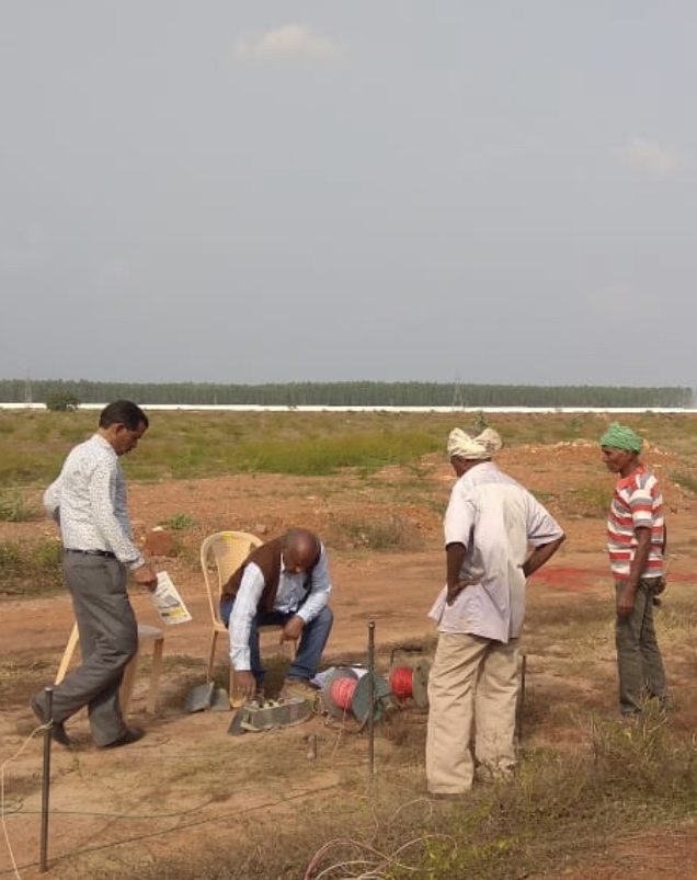
Investigation Methodology
The Geoelectrical resistivity technique uses an artificial current source whereby a low frequency (4HZ) current is used. Controlled amount of current is introduced into the ground through current electrodes and measurements are carried out with the help of potential electrodes.
The current and potential electrodes are placed in various configurations, but the most extensively used electrode configuration for subsurface investigation is the Schlumberger Configuration. In this configuration the four electrodes are placed symmetrically along a straight line, the current electrodes are on the outside and the potential electrodes on the inside along the array.
With this configuration, to change the depth range of the measurements, the current electrodes are displaced outward. When the ratio of the distance between the current electrodes to that between the potential electrodes becomes too large i.e. more than 5 times, the potential electrodes must also be displaced outward, otherwise the potential difference becomes too small to be measured with sufficient accuracy.
In the Schlumberger Configuration, the apparent resistivity (Pa) is calculated by the formula.
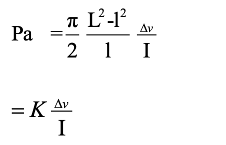
Where, Pa is apparent resistivity.
L is half of the distance between current electrodes.
l is the half of the distance between potential electrodes.
π is constant,
∆v is potential difference and
I is amount of current.
K is a constant known as Geo-electric factor and based on the type of electrodes configuration.
Geophysical measurements are based on the assumption that the subsurface consist of a sequence of distinct layers of finite thickness, each of these layers is assumed to be electrically homogeneous and isotropic and the boundary planes between subsequent layers are assumed to be horizontal.
The resistivity data are interpreted using the Schlumberger Sounding Data Processing and Interpretation Programme.
For ascertaining ground water levels, the resistivity response depends primarily on the amount of impregnating water, the conductivity and quality of water and manner in which water is distributed. The first two factors have a nearly linear relation with the resistivity while the influence of the third factor is more complicated and depends on the nature of aquifer material.
In summary, it can be stated that a dry soil formations, whether porous or non porous are practically poor conductors and hence the resistivity will vary with amount of pores and quality of water. The chemical quality of ground water corresponds with aquifer resistivity.
LIMITATIONS:
There are certain inherent limitations in estimating water withdrawal levels and lithology, which are being mentioned as under:-
1. Scientific and human error possibilities to the extent of 15% cannot be ruled out both in quantitative and qualitative assessment of ground water.
2. Increased ground water development activity in and around the area investigated may also effect rate of subsurface flow of water in the area in the years to come.
Thus, any recommendations for construction of structures (Tube- well/ Dug cum bore well) for ground water development are based on indirect science of Geophysical investigations.
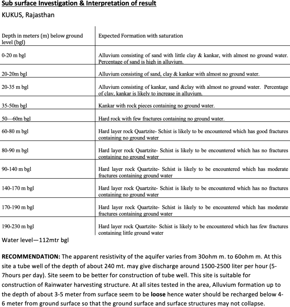
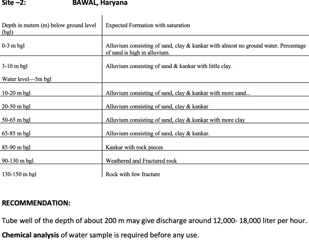
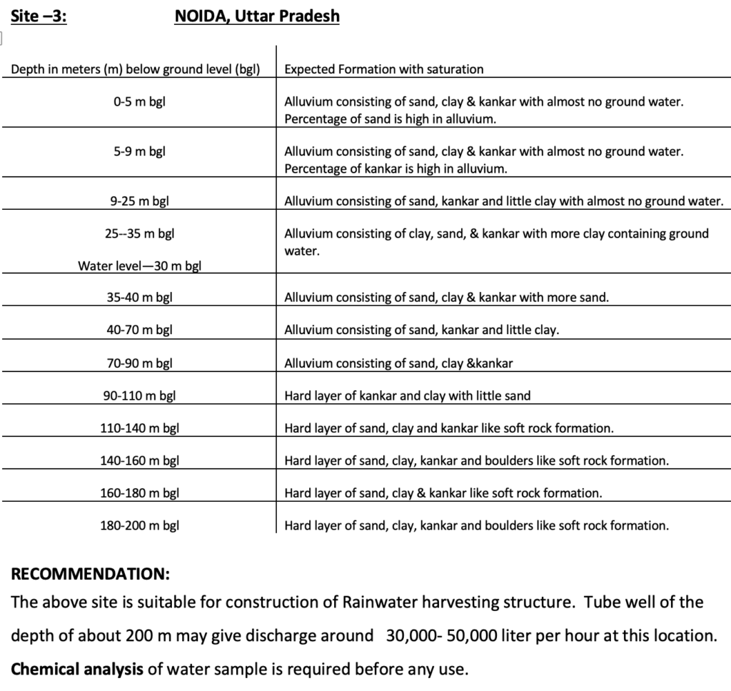
Presented below are data from 3 different sites to show different soil formations calling for appropriate modifications in rain water harvesting designs.
